Water resources knowledge and monitoring for the Niger river

Climate change adaptation in the River Niger Basin

Water resources knowledge and monitoring for the Niger river

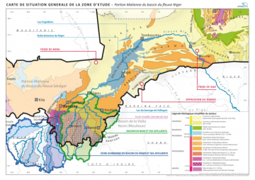
The River Niger crosses five countries in West Africa (Guinea, Mali, Niger, Benin, and Nigeria), but its basin is shared by ten countries, including Cameroon, Burkina Faso, Ivory Coast, Chad, and Algeria, in addition to the countries previously mentioned.  It is the primary source of water supply for more than 100 million people.

As a member of the Niger Basin Authority (NBA),  Mali has engaged in a process to manage the river basin’s resources. This initiative has highlighted the lack of knowledge on surface water and groundwater exchanges in the River Niger basin.

This project is part of the NBA’s “Adapting to Climate Change in the Niger Basin Integrated Program” and benefits from the support of German financial cooperation through KfW.

Challenge

Antea Group teams are providing international expertise and contributing to improving fundamental knowledge on strategic water resources for a huge region, particularly vulnerable to the impacts of climate change. One of the main challenges faced by this project comes from the large distance to be covered in auditing the system already in place with ten river flow rate measuring stations in a region that is difficult to access. Beyond improving the network’s measurements, this is a complex large scale environmental data management project (measurements, compilation, modeling, skills transfer, and the creation of decision-making tools at a national level).

Solution

This mission focuses on elements of the Niger basin and its management: hydrology, hydrogeology, databases and modeling capacity for its entire length in Mali, i.e. 1,750 kilometers with works on instrumentation in the hydrometric station network and support in monitoring 100 hydrometric stations and 70 piezometers).

The project covers an assessment on the level of knowledge on water resources in Mali and its monitoring, summary preliminary design and final preliminary design studies and invitation to tender documents, assistance in procurement, in project supervision of works for establishing additional hydrometric stations and 70 piezometers.  Antea Group is also providing technical assistance in operating and maintaining the optimized network. This project also includes the modeling of the global River Niger basin in order to quantify available water resources, evaluate uses and develop a tool to help in decision-making for the future allocation of uses of the available water mass. Besides, Antea Group is contributing in boosting the NMHD’s (National Mali Hydraulic Department) capacity to use the tools implemented independently.

Key Figures

  • 1,750 km of works
  • 100 hydrometric stations
  • 70 piezometers
  • 900 km of river banks

This website uses cookies

Functional and analytical cookies are placed with every visit without requiring permission. Use of the Social Media buttons depends on the privacy statement and cookie policy of the relevant social network. Targeting cookies from third parties are only placed if you give your consent. Select the type of cookies you want to accept.

More information