IWRM program for Lullemeden - Taoudeni/Tanezrouft Aquifer Systems

IWRM program for Lullemeden - Taoudeni/Tanezrouft Aquifer Systems

Integrated Water Resource Management for the Iullemeden (SAI), Taoudeni/Tanezrouft (SAT) Aquifer Systems and the Niger river

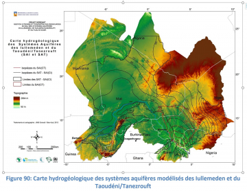
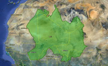
The Iullemeden (SAI) and Taoudeni/Tanezrouft (SAT) aquifer systems globally cover a surface area of 2.5 million km² and extend to seven African countries (Benon, Burkina Faso, Mali, Mauritania, Niger, Nigeria and Algeria). The ground water from these aquifers are the main resource for the populations of the six countries in question. In one part of the SAI, water resources are overused. As for the Taoudeni/Tanezrouft (SAT) aquifer system, it is less well known and had not been the subject of a general study. The Sahara and Sahel Observatory (OSS) received a donation from the African Development Bank to launch the study in order to improve water resource assessments, cross-border risk management, and to set up a framework to discuss the shared water resources in the vast area.

Challenge

The project’s specific targets were the following:

  • To update and improve knowledge of this system in order to make a management tool available to national decision-makers and managers that will make it possible to globally:
    • Know the hydraulic potential of the aquifers both in terms of quantity and quality;
    • Simulate water table behavior when faced with water demand from each country;
    • Identify the cross-border hydro-geological risks;
    • Offer elements allowing to choose an integrated water resource management strategy programmed in line with the targets sought by each country.
  • Analysis and Management of Cross-Border Risks for the SAI, SAT and Niger river, including an assessment of vulnerability and the impacts of climatic change on the SAI, SAT and Niger river water resources.

Strengthening of management capabilities by training technicians from the countries on water resource management tools (Database, Geographic Information System, Modeling), remote detection, and by the organization of awareness raising workshops on the process and the need for collaborative resource management.


Solution

The Antea teams were faced with multiple challenges for this non-standard project. In fact, they had to create a model of the flows and ground water resources for a region as big as half the European Union, collect data spread over many state organizations, and acquire additional data from the field.  To that was the added difficulty of regional politics when setting up a mechanism to consult the authorities of six countries, the long-term projection of their water requirements, and the identification of cross-border risks. This made it possible to define a strategic water resource vulnerability assessment and the impacts of climate change.

Finally, the last factor contributing to the difficulties consisted in strengthening the technical skills of the stakeholders’ technical institutes and implementing tools to centralize and use this environmental data. This was made possible by the double skills of our teams covering both the hydro-geological field and the development of new adapted software.


Key Figures

  • 2.5 million km² aquifers' surface area
  • 520 k€ Total fee amount
  • 7 impacted African countries