Integrated Water Resource Management Program for West African River Basins

Integrated Water Resource Management Program for West African River Basins

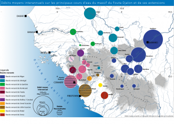
Development of a water atlas for the Fouta Djallon Highlands and support for the validation of IWRM directive in West Africa

Since 1998, the countries of West Africa have been strongly committed to a regional process of integrated water resources management (IWRM).  This resulted in December 2000 in the definition of a regional action plan for IWRM in West Africa to help the Economic Community of West African States (ECOWAS) in implementing fair and effective water management guaranteeing the sustainability of water uses. Since 2016 Antea Group France has been committed to developing a regional framework and a range of tools to enable countries and basin organizations to make quicker and more concerted progress towards practical measures in order to implement IWRM.

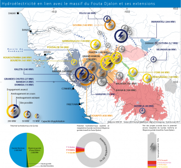
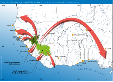
Antea Group France carried out 3 projects to develop tools to aid the creation of a regional policy for the water sector in the ECOWAS region through: (Focus 1) the preparation of a directive on shared water resources management, (Focus 2) a study to evaluate the participation of West African river basin organizations (RBOs) in regional IWRM and (Focus 3) the management and sharing of information on the region’s valuable water asset : the Fouta Djallon Highlands Atlas.

Assistance in preparing the IWRM Directive

Preparation and organization of a regional workshop to approve the directive on the management of shared water resources in West Africa (15 ECOWAS member countries).

Expert analysis and review of the draft directive and proposed amendments. Assistance in adopting the directive.

Assessment of IWRM development status in ECOWAS

Surveys and meetings with the various West African river basin organizations (RBOs) in the ECOWAS (ABN, OMVS, OMVG, ABV).

Expert analysis report on the activities conducted with the RBOs.

More in-depth case study on the relationships between the RBOs and the national basin management entities.

Expert analysis report and workshop for final submission of the works conducted in this focus.

Fouta Djallon Atlas

Monographic summary of the Fouta Djallon Highlands water resources and associated uses (47,000 km², 20 river basins in 4 countries: Guinea, Mali, Senegal, Sierra Leone).

  • Definition of the physical framework of the Fouta Djallon and its watershed
  • Definition of the highland’s water resources: main river flows and their hydrological patterns and overview of groundwater resources.
  • Inventory on water uses by the population and agricultural activities as well as fishing, hydropower and mining activities.
  • Analysis of stakes and challenges.

Collection of data, information and desk top study and structuring of the information collected in a GIS-coupled database. Compatibility of the GIS-coupled database with the design of the ECOWAS Water Observatory’s centralized information system.

Downloads

Key Figures

  • 4 countries directly concerned: Guinea, Mali, Senegal, Sierra Leone
  • 47 000 km² of impacted area
  • 20 river basins
  • 15 transboundary basins including Senegal, Gambia Niger, Rio-Corubal, Great Scarcies and Little Scarcies

Other water projects

Check out our water services

alt-text

Drinking water & Sanitation

alt-text

Coastal and estuaries resilience

alt-text

Integrated Water Resources Management (IWRM)

alt-text

Multi-Hazard Risk Management

alt-text

Industrial water treatment

alt-text

Water Stewardship

This website uses cookies

Functional and analytical cookies are placed with every visit without requiring permission. Use of the Social Media buttons depends on the privacy statement and cookie policy of the relevant social network. Targeting cookies from third parties are only placed if you give your consent. Select the type of cookies you want to accept.

More information